
Marine Investigation Report M00C0019
Grounding
Chemical Tanker Sunny Blossom
Lac Saint-François
St. Lawrence Seaway
The Transportation Safety Board of Canada (TSB) investigated this occurrence for the purpose of advancing transportation safety. It is not the function of the Board to assign fault or determine civil or criminal liability. This report is not created for use in the context of legal, disciplinary or other proceedings. See Ownership and use of content.
-
Table of contents
Summary
The Sunny Blossom was on Lac Saint-François bound for Cornwall, Ontario, in daylight and in reduced visibility. A pilot, accompanied by an apprentice pilot, had the conduct of the vessel. Following a course alteration off Pointe Dupuis, the vessel ran aground upstream of buoy D36 on the north side of the channel at 0730. The grounding caused some delays to vessel traffic in the area. The vessel was refloated the following day with the assistance of a tug. The grounding did not cause damage to the vessel or pollution. No one was injured.
Factual information
Particulars of the vessel
| Name | "SUNNY BLOSSOM" |
|---|---|
| Official Number | 715942 |
| Port of Registry | Nassau, Bahamas |
| Flag | Bahamas |
| Type | Chemical Tanker |
| Gross TonsFootnote 1 | 11 598 |
| Length | 160.8 m |
| Draught | Forward: 7.86 m Aft: 7.9 m |
| Built | 1986, Minami-Nippon, Usuki, Japan |
| Propulsion | Mitsui-B&W diesel, 5146 kW |
| Cargo | 14 413 tonnes of sodium hydroxide (caustic soda) |
| Crew | 21 |
| Owner | Yellowfin Shipping Co. Ltd., Gibraltar |
Description of the vessel
The Sunny Blossom is an ocean-going chemical tanker of 19 995 deadweight tonnes, with its bridge, accommodation, and machinery located aft of its cargo tanks. Chemical cargo, such as sodium hydroxide (caustic soda), is usually carried in five centre tanks. The empty side tanks, together with the continuous double bottom, provide "double hull" environmental protection.
The vessel is fitted with a single rudder and the main engine drives a fixed-pitch, right-handed propeller. The ratio of rudder area to underwater lateral profile of the vessel when fully loaded is in the order of 1:65, which is within established norms for this type and size of vessel.
The vessel is equipped with a Kawasaki Heavy Industries, Ltd. ram-type, electro-hydraulic steering gear. After the occurrence, while the vessel lay at anchor, rudder movement was found to be 34° to port and to starboard. The time taken by pump No. 1 to complete full rudder movement (34°, 0°, 34°) was 28 seconds, and the same sequence by pump No. 2 took 26 seconds. With both steering pumps in operation, full rudder movement was timed at 26 seconds, which is within the regulatory time frame. When the helm at the steering station on the bridge was midships, the bridge helm indicator showed a helm angle of 1° to starboard and the steering compartment indicator showed a helm angle of slightly more than 1° to starboard.
History of the voyage
Having sailed from Plaquemine, Louisiana, with a reduced cargo deadweight of 14 413 tonnes of sodium hydroxide (caustic soda) solution, the Sunny Blossom departed Montréal, Quebec, on 17 May 2000 at 2029 eastern daylight time (EDT)Footnote 2 for discharge of cargo at Cornwall, Ontario.
The vessel was carrying 72 per cent of its maximum cargo deadweight at a reduced draught of 7.88 m for Seaway navigation, and had a small trim by the stern.
After an uneventful voyage from Montréal to Upper Beauharnois Lock No. 4, a change of pilot took place for the second part of the transit in the St. Lawrence Seaway. An apprentice pilot accompanied the pilot. The master/pilot exchange included an overview of the pilot card and a discussion concerning the vessel's draught.
On leaving Beauharnois Lock No. 4 at about 0440, the Sunny Blossom was moving ahead at about 6 to 7 knots (kn) when the apprentice pilot ordered "two, zero, eight." The helmsman applied helm, but it was deemed insufficient and helm orders were given by the apprentice pilot to increase the rate of turn and eventually bring the vessel on course. When the apprentice pilot commented on the sluggishness of the vessel, the officer of the watch (OOW) informed him that both steering pumps were on. Neither the pilot nor the apprentice pilot observed the pump selector switch on the steering console; they relied on the information given by the navigating personnel.
At 0448, the speed of the vessel was increased from half ahead (7 kn)Footnote 3 to full manoeuvring speed (11.2 kn). The apprentice pilot continued to give helm orders to the helmsman and engine orders to the OOW. Visibility in the area was estimated to be approximately 3 nautical miles (nm). At the Valleyfield bridge, rain reduced the visibility to 2 nm. At 0610, the speed of the vessel was increased to full sea speed (14 kn). At about 0627, on the Pointe aux Foins downstream range, the pilot took over the conduct of the vessel. Thereafter, the apprentice pilot assisted the pilot with updates of radar information. The rain intensified and reduced visibility to approximately 1.5 nm.

Downstream of buoy D17, at about 0650,Footnote 4 the pilot ordered "port ten" to alter course in a single turn from the Pointe Beaudette ranges at 242° True (T) to Île Chrétien ranges at 209° T. As the heading neared 209° Gyro (G),Footnote 5 the pilot ordered the helmsman to steer 209° G, but the vessel continued to swing to 205° G. The helmsman applied helm to steady the vessel, but it swung to 223° G. The pilot gave the helmsman a succession of orders to steady the vessel's heading on 210° G (Appendix B, Sketch 2). After the vessel had steadied on 210° G upstream of buoy D17 on the Île Chrétien range, the pilot and the OOW discussed the helmsman's performance. Reportedly, it was the second time the helmsman had experienced difficulty in steadying the heading. The OOW ordered the third officer to replace the helmsman. When the third officer walked to the steering station, the helmsman on duty informed the chief officer (OOW) that he thought he was fit to steer. He was permitted to continue steering the vessel. The next course alteration onto the Pointe Dupuis range was uneventful.
Fog and rain further reduced visibility. Winds were light. At 0710, downstream of buoy D26, the engine was reduced from full sea speed to full manoeuvring speed. At 0722, before clearing buoy D31, speed was further reduced to half ahead (7 kn). Measuring the distance to the radar target of buoy D31, which was at the limit of visibility, the apprentice pilot found that visibility had decreased to 0.35 nm.
At 0726, the course steered was altered from 236° G to 234° G, and the vessel crossed over to the south side of the channel. When the apprentice pilot advised the pilot that the vessel was 0.81 nm from Saint-Anicet lower range beacon and 0.36 nm from Île Lanouette, the pilot ordered the helmsman to apply 10° starboard helm. Buoys D34 and D35 were then observed as the vessel rounded between them. As the radar heading marker neared the south side channel target of D37 at 0727, the pilot gave helm orders to reduce the vessel's swing and then told the helmsman to steer 247° G. Buoy D37 could now be seen on the starboard bow. The pilot confirmed this visual cue by going to the radar and observing the buoy at a distance of 0.31 nm.
At about 0729, the vessel began to yaw to port and the pilot ordered "hard-a-starboard." The heading stopped falling off at 246° G and the helm was eased to starboard twenty. When observing buoy D37 ahead, the vessel's response was found to be sluggish and the helm was once again put hard over to starboard. The vessel started to respond and, when the heading reached 250° G, the pilot ordered "steer two six seven." The third officer informed the apprentice pilot that the next course was 266.5° G and that he agreed with the pilot's order. As the vessel cleared buoy D37 on the south side of the channel, the third officer remarked that the vessel was very close to the buoy. The pilot repeated the order "course two six seven." By now, the rain had intensified to the extent that visibility was almost nil.
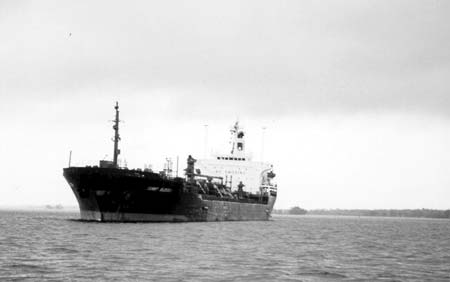
The apprentice pilot observed that the heading markers of both radars were approaching 280° G and advised the pilot accordingly. The pilot went to the radar, commented on the poor radar performance and immediately ordered the OOW to reduce speed from about 7 kn to the dead slow ahead speed of 5 kn. The vessel continued to swing to starboard across the channel. There is conflicting information as to what helm orders were given. One account maintains that there was no time to give helm orders, whereas another account maintains that a series of port helm orders was given. At 0730, the chemical tanker grounded upstream of buoy D36, on the north side of the channel, on a heading of 274° G. The vessel was aground starboard side to the shoal with a list to port of 2.5° (Appendix A, Photo 1).
At 0735, the grounding of the Sunny Blossom was reported to Seaway Eisenhower. Seaway traffic was interrupted from 1130 until 2300. On 19 May 2000 (the next day) at 0911, with the assistance of tugs Ocean Intrepid and H-9901, the chemical tanker was refloated. No damage was apparent and apart from an accumulation of clay over the bottom, only minor scratches were reported. The grounding did not affect the integrity of the hull nor the seaworthiness of the vessel. At 1600, the vessel was given clearance by the St. Lawrence Seaway Management Corporation to resume its voyage.
Certification of Vessel and Personnel
The Sunny Blossom has been calling at Canadian and United States ports on the Atlantic coast and in the Great Lakes for several years. It was certificated and equipped in accordance with existing regulations.
The chief officer, 4–8 OOW, was in possession of a Deep Sea Navigator Certificate of Competency, issued by the Republic of Latvia in 1997.
The third officer, who was also on duty at the time of the occurrence, was in possession of a Third Mate Certificate of Competency, issued by the Republic of the Philippines in 1992, and an equivalent certificate issued by the Bahamas in 2000.
The helmsman on duty at the time of the occurrence held a Rating's Certificate of Competency, issued by the Republic of the Philippines in 1996, to perform duties relevant to navigational watchkeeping.
The pilot on duty at the time of the occurrence held a Certificate of Competency for a Master of a Home-Trade Steamship of under 350 gross tons, issued in 1962, and a First Mate of an Inland Waters Steamship, issued in 1974. He was also in possession of a Great Lakes Pilotage Authority (GLPA) licence for the District of Cornwall, issued in 1976.
The apprentice pilot held a Certificate of Competency as an Ocean Navigator I (Master of a Home-Trade Steamship), issued in 1985, and his certificate is endorsed for Standards of Training, Certification and Watchkeeping (STCW) compliance and continued proficiency (2001). He also held a GLPA licence as an apprentice pilot for the District of Cornwall, issued in 1999.
Personnel history
The first officer had some 22 years of sea service. In 1979, he had begun serving as OOW.
The helmsman on duty at the time of the occurrence had been a helmsman since 1994. He had joined the vessel on 01 May 2000, and had previously held a similar position on an ocean-going chemical tanker.
The pilot on duty at the time of the occurrence had some 45 years of sea service, of which some 24 years of sea time were acquired as a licenced pilot. Among his continued proficiency training, he had attended a Simulated Electronic Navigation (SEN II) course in 1990, and had completed an Electronic Chart Display and Information System (ECDIS) course in 1999.
The apprentice pilot commenced his apprenticeship with the GLPA in 1999.
Weather information
At the time of the occurrence, visibility was almost nil in heavy rainfall and fog, with southeasterly winds at some 3 kn. The air temperature was 15°C.
Current Information
Southwest of calling-in point No. 7, the waterway extends in a 234.5° T direction, passing south of Pointe Mouillée Flats and north of the Saint-Anicet shoal. From buoy D33 to buoy D35, the waterway is approximately 400 m wide at an average depth of 13.5 m.Footnote 6 Upstream of buoy D35, the waterway narrows to a 137 m-wide channel at an evenly dredged depth of 8.7 m. The narrow channel extends in a 266.5° T direction through Lancaster Bar.
The depth of water as plotted by the Summerstown tide gauge recorder for 18 May 2000, at around 0730, was 0.42 m above chart datum. The current off Island Bank is reported to set to the northeast at approximately 1.5 to 2 kn.
Pilotage and Bridge Management
Except for the aids to navigation, such as the ranges and the buoys, there are no prominent landmarks in the Pointe Dupuis area. The upbound course alteration off Pointe Dupuis, from the Saint-Anicet west range onto the Pointe Dupuis range, is a 32° turn, which calls for a close port-hand approach to light buoy D37.
In way of buoy D33, the vessel is made to gradually cross over onto the south side of the channel. The turn is commenced abeam Île Lanouette from a heading of 235° T, followed by an intermediate course of 247° T, and completed by a final heading of 267° T to enter the dredged channel. A bank cushion effect is used to proceed along the port-hand buoys in the dredged channel upstream of D37. This manoeuvre has been adopted by all pilots transiting upbound because it enables the vessel to compensate for the drift due to the current, which sets northeast. Downbound vessels that must meet in this area pass starboard to starboard.
The chief officer, who was the OOW, stood by the engine telegraph on the starboard side of the bridge while the third officer plotted the position of the vessel on the chart with information from one of the radars on the port side. The helmsman performed his duties at the steering station. Both the pilot and his apprentice pilot monitored the progress of the vessel visually from the forward bridge windows in way of the central gyro-compass repeater and/or from either of the port radars.
During the trip, the pilot was engaged in tutoring the apprentice pilot and this communication was conducted in French. All navigation orders such as course, helm and engine telegraph orders were given in English, which was the working language of the ship's officers and crew. However, in the vicinity of buoy D35, critical information essential to safely negotiate the turn was not shared with other members of the bridge team.
Situational Awareness
The maintenance of situational awareness in confined/pilotage waters, particularly in conditions of reduced visibility, is a demanding task for the navigator. The task requires that cues, both visual and from aids to navigation and instruments, be sampled and integrated, and that this information be projected ahead to determine the action to be taken.
In good visibility, navigators use visual cues in their immediate and extended surroundings to determine orientation, rate and direction of movement, distance from obstacles on or near the vessel's track, and the avoidance of these obstacles. While the information available with direct vision in good visibility is adequate, the limited information obtainable in restricted visibility is not. In this occurrence, the poor visibility reduced the navigators' ability to resolve the limited visual cues available.
Electronic Chart System
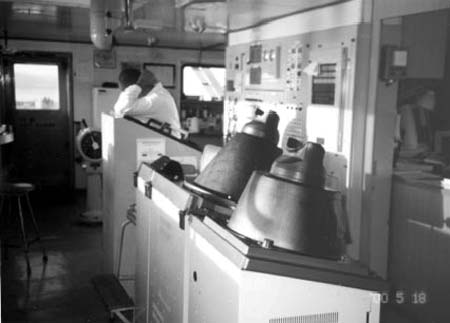
The vessel was fitted with an electronic chart system (ECS). It had been installed on the chart table console, abaft the steering station, the vessel having a traditional bridge layout with chart table in the after part of the wheelhouse (Appendix A, Photo 2).
The International Maritime Organization (IMO) type-approved ECDIS and the non-approved ECS offer numerous benefits compared to conventional navigation, such as automatic display and updating of own-ship position, and the capability to overlay radar information. Although it is not mandatory to carry an ECDIS or ECS, or to be trained in the use of these systems, the advent of these automated systems is a significant step toward increasing operational efficiency, situational awareness, and safer navigation.
The ECS installed on the Sunny Blossom was not calibrated with the on-board global positioning system (GPS) and was, therefore, not available for safe navigation. Both the crew and pilot were aware of this, and it was not used during the course of the voyage.
The watch officers had not received training, and did not appear to be proficient in the use of the ECS. They had instituted an informal in-house training routine among themselves. Arrangements had been made to have the system re-calibrated when the vessel arrived at Cornwall. Therefore, the ECS was not being used as a primary source of navigation information.
Analysis
Manoeuvring
Given that the rudder area ratio was within established norms, and the on-site steering gear performance tests on the Sunny Blossom were satisfactory, the vessel cannot be characterized as having slow and/or sluggish manoeuvring capabilities when operating under normal service conditions. However, the ship's manoeuvring characteristics can vary considerably depending on the following:
- the intensity and direction of wind;
- the wave action;
- the current;
- water depths if less than twice the vessel's draught;
- the cleanliness of the hull; and
- whether the ship is at an intermediate draught or has unusual trim.
The Sunny Blossom was sailing at a reduced draught of 7.88 m for Seaway navigation and had a small trim by the stern. The intermediate draught represented 86 per cent of the summer salt water draught of 9.15 m. This draught is a principal design parameter in determining the appropriate rudder area for optimum manoeuvring considerations. Consequently, at this lesser draught, the vessel was likely to have been more responsive to helm changes than it would have been in deep water.
The apprentice pilot commented on the sluggishness of the vessel when leaving the shallow channel exit from the Beauharnois Lock No. 4 at a speed of only 6 to 7 kn. However, this is not an unusual phenomenon for a ship moving in a narrow channel such as the Beauharnois Canal, which has a depth of only 8.2 m (Appendix B, Sketch 1). This phenomenon would also exist for a ship navigating in the Lancaster Channel, where the depth of the water is only 0.5 m more than in the Beauharnois Canal.
Bank suction and squat effects can produce changes in the vessel's directional stability, affecting its response to the helm. Steering difficulties while operating in shallow waters had been experienced on a previous occasion when, on 16 July 1999, the vessel was on a similar voyage to Cornwall.Footnote 7 Also, on 24 April 1999, the Sunny Blossom had ran hard aground in the U.S. section of the Seaway at the eastern entrance to Lake Ontario. On that occasion, environmental concerns were raised when the vessel required the lightening of its dangerous cargo.
Although the helmsman had only served about two weeks on board the vessel, he had gained considerable prior experience as helmsman on a deep-sea chemical tanker. When his performance was questioned by the pilot, following some difficulty in steadying the vessel after a 33° course change, the vessel had been travelling at the full sea speed of approximately 14 kn, about 3 kn more than full manoeuvring speed. It was the largest course change taken in a single turn during the helmsman's watch. At this maximum speed, the vessel's pivot point for manoeuvring was at its most forward position, making the vessel more responsive to helm changes.
When the helmsman's ability to steer had been questioned by the pilot, the helmsman professed that he was fit to steer and, probably with a heightened state of alertness, he executed orders as required and with accurate course-keeping during the manoeuvres leading up to the grounding.
Hydrodynamics
In a channel bend, the path of the water mass is generally parallel to the outside bank of the channel. The direction of the current may be variable inside the bend and the current may be weaker.
When a ship is negotiating a bend in a channel, it is possible to get into a position where the ship is influenced by currents of differing strengths. The bow can be influenced by the strong outside bend current while the after body is in the weaker current. This situation creates a turning moment that opposes the direction of the intended turn and, if it is not anticipated with appropriate helm and power, the vessel may not come around in sufficient time to clear the bend. When a ship is negotiating a bend in a channel, it is better to keep to the inside of the bend so that the bow does not enter the area of stronger current that occurs near the outside of the bend.
In shallow water, the problem is compounded. The Venturi effect of water being forced under the bow, and the build-up of water ahead of the ship, will produce a squat by the bow on a vessel with a large block coefficient, and by the stern on a vessel with finer lines. When the vessel squats by the bow, the theoretical pivot point of the ship will also move further aft.
In addition to the possibility of grounding forward due to squat, there also exists the possibility of a loss of directional stability that can cause the vessel to sheer to one side. If the helmsman allows a small swing to develop, longitudinal pressure forces will be brought to bear on the bow and this will augment the rate of swing. Counter helm to correct the swing may be sluggish because the steering lever is reduced.Footnote 8
At full-ahead speed, the theoretical pivot point is approximately one-quarter the ship's length from forward. If the speed of the ship is reduced, the resistance created by the water ahead of the vessel will reduce and the pivot point will move aft. In shallow water, slowing a vessel with a large block coefficient such as the Sunny Blossom will also reduce the squat by the bow.
Prelude to Grounding
The radar coordinates taken at the approach to the bend between buoys D34 and D35 reveal that the Sunny Blossom was manoeuvred as anticipated, toward the south side of the channel. Adequate helm orders were given by the pilot and applied by the helmsman to reach the intended intermediate course, i.e. 247°. The resistance encountered in continuing the course alteration to starboard is consistent with the influence of the strong current on the ship's bow, normally experienced at an outside bend of a channel. This force reduced the vessel's rate of turn to starboard and momentarily stopped it. The pilot, who was still using visual references, had anticipated this effect and, by giving the appropriate course orders, succeeded in making the vessel come around.
As the vessel proceeded from the waterway into the narrow channel leading to the Lancaster Bar, the bow was closing on the shoal downstream of buoy D37 and the water depth was decreasing rapidly. When the heading was at 250° G and the vessel reportedly cleared close to buoy D37, the heading should have been at 267° G. Holding at 17° off course, it was then that the pilot repeated his order for course 267° G. At that instant, the vessel was moving ahead at about 5½ kn and the channel was at its shallowest.
It is probable that helm changes to achieve course 267° G for entry into the dredged channel should have been made either earlier or by using more rudder angle and that the bow was closer to the shoal than usual. As a result of the bow nearing, or perhaps glancing, this underwater barrier, the ship experienced a bank cushion effect. The positive pressure against the port bow, created by the build up of water, caused the vessel to sheer to starboard. This sheer was exacerbated by a main engine speed reduction and squat effect, which moved the theoretical pivot point of the ship further aft. In turn, this increased the turning lever created by the positive pressure ahead of the ship.
Once the stern neared the side of the channel, the bank suction effect created another turning lever abaft the pivot point. Compounding these resultant horizontal forces was the starboard helm applied to reach the final course, 267° G. With the probable loss of directional stability due to squat, the torque created by the resultant turning lever produced a sudden sheer to starboard, causing the vessel to overshoot.
Electronic Chart System
The ECS could not be used during the course of the voyage as it had not been calibrated with the GPS. Nor could the ECS be used on board the Sunny Blossom at the time of the previous grounding on 16 July 1999 (TSB report No. M99C0027), when the equipment was said to have been recently fitted but was not yet operational. Little progress, if any, had been made in the intervening year to render the system useful or to have the navigating officers properly trained.
Although "in-house" training in the use of the system was being carried out by the deck officers, and the ECS was to be re-calibrated upon arrival in Cornwall, the effort to maintain the equipment in good order and to provide effective training in its use falls short of the intent of the IMO conventions and related recommendations. It is essential for users to complete IMO-recommended formal instruction. Maritime training centres have access to the IMO-recommended syllabus for ECDIS/ECS training, which can supplement any existing courses on the subject.
It is incumbent upon the shipowner to ensure that equipment placed on board is functional and well maintained. Without formal training, the improper use of an ECS can be detrimental to the safe navigation of the vessel.
There is no government approval on the use of this modern navigational aid as yet. However, had the ECS been functional and optimally positioned, and the officers well versed in its use, it would have provided the bridge team an additional tool to monitor the vessel's progress and a means to better maintain situational awareness under difficult conditions.
Situational Awareness
To maintain situational awareness, the navigator needs to refer to, or sample, a large amount of data from a variety of sources, both on board and external to the vessel.
The Sunny Blossom was not equipped with a modern type of bridge layout. Those who controlled the vessel's movement had to look above the central forward window to see the helm indicator, look toward the starboard side of the bridge to confirm the engine telegraph setting, walk to the port side of the bridge to monitor the radars, and walk to the chart table abaft the central control panel to read the chart or monitor other navigation equipment.
Just prior to the grounding, the pilot was standing at the forward bridge windows. Up to that time, conduct of the vessel had been done mainly by visual observation. The pilot concentrated his attention on visual cues, his primary source of information. The radar had been used as a secondary source, with the apprentice pilot providing information on the ship's heading and relative position.
Visibility was reduced to 0.35 nm just eight minutes before grounding, by which time it had been further reduced to almost nil. When the rain intensified to the extent that visibility tended toward zero and the outside visual cues were obscured, the pilot's ability to project the vessel's track was reduced. His spatial and real-time resolution of visual cues was reduced. His only recourse was to monitor the on-board aids to navigation and instrumentation. By the time he had walked to the radars to confirm the vessel's heading and rate of turn, it was too late for him to correct the situation.
Spatial disorientation may occur when information available from visual cues seems incomplete or contradictory. The solution to spatial disorientation is for the navigator to be continuously aware of, and to trust, the most reliable sources of information available, before visibility is reduced. In restricted visibility, these sources will invariably be the on-board aids to navigation and instruments.
Bridge Resource Management
To successfully negotiate the turn in the vicinity of buoy D35, it was necessary for the vessel to be positioned south of the centre of the channel to counter the effects of bank suction. However, this information was not shared with other members of the bridge team. This precluded the OOW from effectively participating in the navigation of the vessel. Consequently, when the third officer questioned the manoeuvre and received no response from the pilot, he acquiesced and the benefits of team synergy were lost.
Close monitoring of a vessel's movement is critical to navigating safely in confined waters. Time is of the essence when initiating and executing manoeuvres. Therefore, it is essential that each bridge team member fully understands his/her role and ensures that any information that can favourably or adversely affect vessel navigation be communicated to the person in charge of pilotage/navigation.
Not implementing Bridge Resource Management (BRM) precepts, such as effective communication or the exchange of information, has been identified in a number of occurrences.Footnote 9 Concerned that a lack of BRM training among bridge personnel increases the probability of accidents in confined Canadian pilotage waters, the TSB issued recommendation M99-05, which requested that the Department of Transport and the Canadian pilotage authorities develop and implement a BRM training validation system to help ensure that the principles of BRM are being put into operational practice.
Amendments to the General Pilotage Regulations came into force on 30 March 2000. Section 11 of these regulations requires that, beginning on 01 January 2005, licences and pilotage certificate applicants or holders hold a certificate of attendance at a BRM training program recognized by the pilotage authority as meeting the requirements of Part B, Chapter VIII of the STCW Convention.
The four pilotage authorities and the Canadian Marine Pilots Association have agreed to put into place a training committee within each region to examine all training requirements to ensure the continuous proficiency of pilots. A Pilot Continuous Proficiency Report, which contains specific training objectives for each pilot, including BRM, will be reviewed every five years, and a training initiative will be discussed with each pilot.
The practice of BRM principles on the Sunny Blossom would have provided an opportunity to better the synergy of the bridge team and enhanced the effective tracking of the vessel's progress. Team awareness of the situation may have provided collective assistance to the navigators in attaining the correct course at the entrance to the dredged channel at an earlier stage.
Findings
Findings as to causes and contributing factors
- The Sunny Blossom was off course to port by approximately 17° when it cleared buoy D37 upon entering the narrow dredged channel.
- The vessel experienced the effects in shallow water of squat at the bow and bank suction at the stern, which caused a loss of directional stability.
- Positive water pressure on the port bow as it encountered the south side of the channel, together with bank suction at the stern and starboard helm, caused the vessel to sheer suddenly to starboard.
- Action to correct the sheer was delayed due to the bridge team's difficulty in detecting the sheer in the conditions of restricted visibility.
- The sheer to starboard was not brought under control in time to avoid the vessel overshooting and grounding.
Findings as to Risks
- The vessel did not respond well to helm changes at half-ahead speed in shallow water, presenting the risk of grounding in narrow channels.
- An over-dependancy on visual aids, when visibility was steadily decreasing, reduced the navigators' situational awareness to the point where they became disoriented.
- The lack of Bridge Resource Management lessened the effectiveness of tracking the vessel and nullified any provision for the bridge team to assist the pilot in the navigation of the vessel.
This report concludes the Transportation Safety Board's investigation into this occurrence. Consequently, the Board authorized the release of this report on .
Appendices
Appendix A - Photos

Appendix B - Sketches

