Controlled flight into terrain
Aircraft Guaranty Corp Trustee
Bell 206B (helicopter), N617TT
Revelstoke Aerodrome (CYRV), British Columbia, 11 NM ENE
The Transportation Safety Board of Canada (TSB) investigated this occurrence for the purpose of advancing transportation safety. It is not the function of the Board to assign fault or determine civil or criminal liability. This report is not created for use in the context of legal, disciplinary or other proceedings. See Ownership and use of content. Masculine pronouns and position titles may be used to signify all genders to comply with the Canadian Transportation Accident Investigation and Safety Board Act (S.C. 1989, c. 3).
History of the flight
On 05 January 2024, the Bell 206B helicopter (registration N617TT, serial number 1049)The aircraft was registered in the United States to the Aircraft Guaranty Corp Trustee of Oklahoma City, Oklahoma, United States, and was privately operated under Part 91 of Title 14 of the Code of Federal Regulations (CFR), “General operating and flight rules.” departed High River Aerodrome (CEN4), Alberta, on a visual flight rules (VFR) flight to a private property in Sicamous, British Columbia (BC), with only the pilot on board. The helicopter was refuelled with 308 L of Jet A fuel before it departed at approximately 1426.All times are Pacific Standard Time (Coordinated Universal Time minus 8 hours).
During the flight, the pilot received information via a text message that stated he would encounter low clouds at Canmore, Alberta. At 1533, the pilot sent a reply indicating that he had encountered poor weather and would take the VFR route along the Trans-Canada Highway through Rogers Pass, BC. On prior occasions, when weather allowed, the pilot had flown over the mountains direct to the private property in Sicamous.
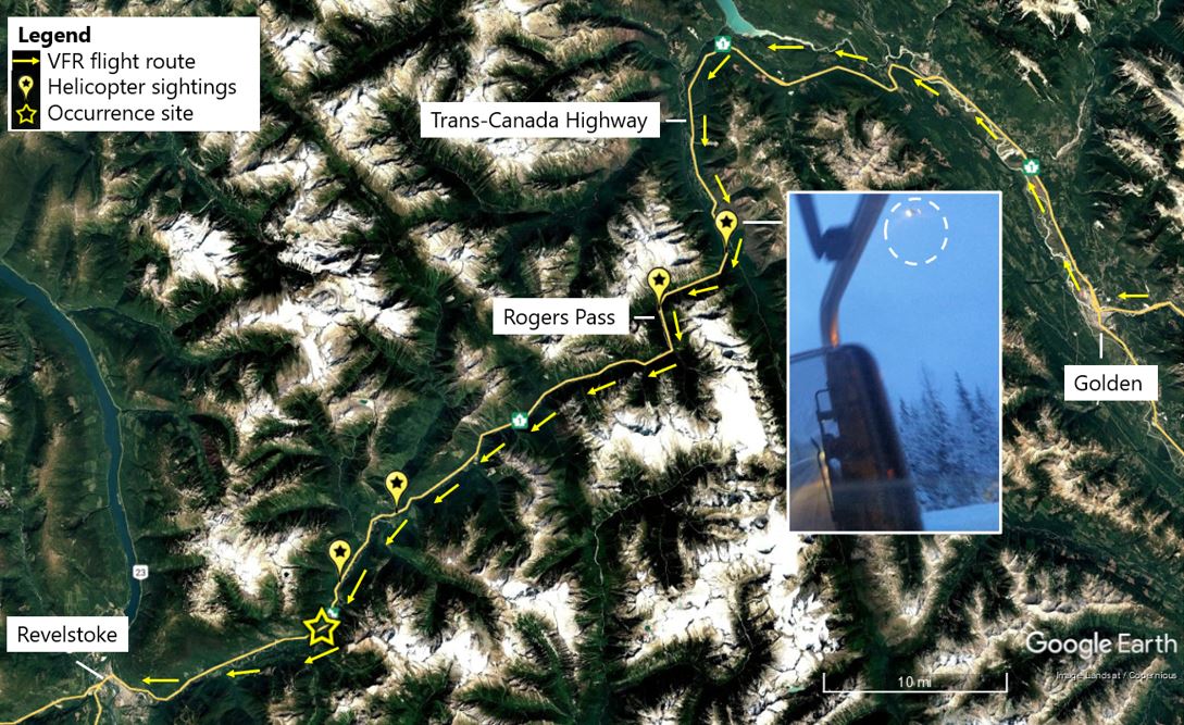
The occurrence helicopter was spotted by motorists and witnesses at various locations along the VFR route (Figure 1). At 1622, the helicopter was first seen approximately 5 nautical miles (NM) north-northwest of Rogers Pass with the forward landing light on and flying in the valley below the cloud toward the pass.
The helicopter was last seen about 20 NM southwest of Rogers Pass, flying southwest in fog at approximately 50 to 100 feet above the trees on the south side of the highway. The helicopter was observed on 3 occasions making 360° left-turn orbits before returning to the same position on the south side of the highway. At approximately 1640, the helicopter made a right turn in a northwest direction and flew across the highway toward upsloping terrain. No further visual contact was reported.
Search and rescue effort
A signal from the helicopter’s 406 MHz emergency locator transmitter (ELT) was received by the Canadian Mission Control Centre and relayed to the Joint Rescue Coordination Centre (JRCC) in Victoria, BC, at 1825. Several search and rescue (SAR) units were tasked with the search.
The search was hampered by decreasing daylight, poor weather, and challenging terrain. A Canadian Armed Forces Cormorant helicopter located the occurrence helicopter at 1126 on 07 January 2024. It was in deep snow and on a treed slope approximately 70 feet uphill and north-northwest of the Trans-Canada Highway. The pilot was fatally injured, and the helicopter was destroyed.
Pilot information
The pilot held a Canadian student pilot permit – helicopter, issued on 15 March 2020 and had a valid Category 3 medical certificate.
Based on the pilot’s training record and the occurrence helicopter’s journey log, the pilot had accumulated approximately 220.9 total flight time hours. Of those hours, approximately 205.1 hours were on the occurrence helicopter, including approximately 83.3 hours of solo flight time and 3.2 hours of instrument flight training in simulated instrument meteorological conditions (IMC). Before the occurrence flight, the pilot had last flown the helicopter for 2.9 hours on 20 October 2023.
Records indicate that the pilot had passed the private pilot flight test using the occurrence helicopter and completed the required written examinations. However, there was no record that an application had been filed for a private pilot licence nor was the pilot granted additional privileges on his student pilot permit.
The student pilot permit requires that all solo flights be conducted under the direction or supervision of a flight instructor, which was not the case during the occurrence flight.
Toxicology results found that the pilot had a substance in his blood stream that was not permitted when operating an aircraft. This substance may derive from an illicit drug or from certain medication.
The investigation determined that the substance was present prior to death. However, it could not determine the source of the substance or whether the presence of the substance influenced the pilot’s performance during the occurrence.
Aircraft information
The occurrence Bell 206B helicopter was manufactured in 1973 and equipped with a Rolls Royce Corporation 250-C20B turboshaft engine. Records indicate that the helicopter was modified for instrument flight rules flight and had dual controls installed for flight training.
The aircraft was maintained in accordance with the airframe and engine manufacturers’ recommendations.
Weather information
Forecasted weather
The investigation was unable to determine what weather information the pilot obtained or reviewed before the flight.
The most recent graphic area forecasts (GFAs) for the intended flight route were issued at 0925 and 0926. The reports forecasted that, at 1000, southeastern BC would have a broken cloud layer and patchy moderate icing at 4000 feet above sea level with local cloud ceilings as low as 400 feet above ground level (AGL). The forecasts also called for localized visibility reduced to 2 statute miles (SM) with light rain, snow, and mist. These conditions continued into the next forecast period at 1600.
Sunset on the day of occurrence was at 1601, with the end of civil twilight at 1640.The sunset data applies to Revelstoke, BC, and is the closest dataset to the occurrence location.,National Research Council of Canada, Sunrise/sunset (full year, Civil Twilight) for Revelstoke BC for 2024 at https://nrc.canada.ca/en/research-development/products-services/software-applications/sun-calculator/ (last accessed on 04 July 2025). The occurrence helicopter was last seen flying in fog at the end of civil twilight. The Canadian Aviation Regulations define night as “the time between the end of evening civil twilight and the beginning of morning civil twilight.”Transport Canada, SOR/96-433, Canadian Aviation Regulations, section 101.01(1).
Actual weather
The pilot departed CEN4 in favourable weather for the VFR flight. As the flight progressed beyond Golden, BC, the pilot would have encountered lower ceilings and reduced visibility as he followed the Trans-Canada Highway.
A meteorological assessment conducted by Environment and Climate Change Canada identified a warm front moving across the region that was producing strong winds and reduced visibility. The conditions would have started deteriorating west of Golden with the clouds lowering to a few hundred feet AGL and the potential for icing conditions within that cloud layer. As the helicopter neared Revelstoke, the visibility would have been further reduced by precipitation with an increase in wind speed and turbulence as the warm front passed.
The automated aerodrome routine meteorological report from CYRV had the following special update at 1628:
- Winds from 180° true at 14 knots, gusting to 20 knots
- Visibility of 9 SM
- Light rain
- Overcast ceiling at 4500 feet AGL
- Temperature 1.9 °C and dew point 0.1 °C
- Altimeter setting 29.97 inches of mercury
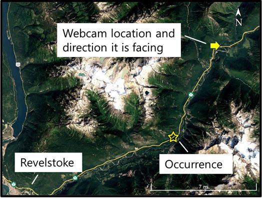
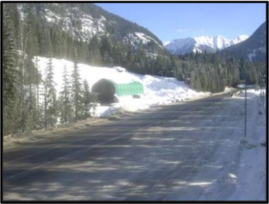
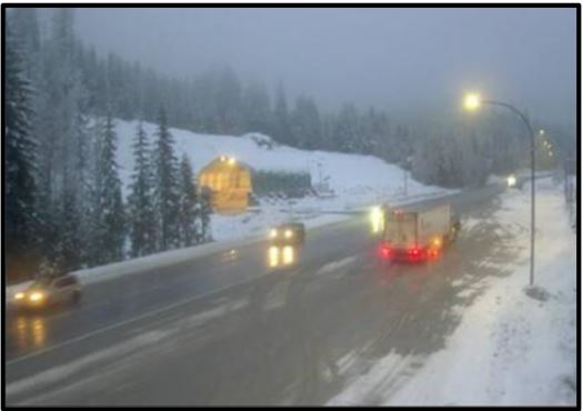
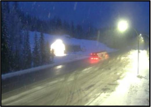
The pilot of a local commercially operated helicopter that was on a return flight from Rogers Pass to Revelstoke reported building fog and cloud layers with light snow showers while passing through the occurrence area at approximately 1600 (Figure 4). As the day transitioned through civil twilight, the visibility likely degraded from a combination of these conditions and the surrounding mountains (Figure 5).
Communications
Before the pilot departed CEN4, he informed a responsible person of his flight itinerary. The pilot and the responsible person communicated via text message to update arrival time and weather.
The JRCC received a report of the overdue helicopter from the responsible person at the same time it received the 1st ELT signal.
The NAV CANADA flight information centres along the flight route had not been contacted by the pilot nor did they provide services to the pilot. NAV CANADA had no record of the flight.
Wreckage information
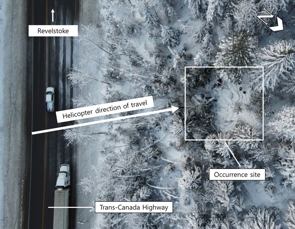
The wreckage was located on a 35° forested slope north-northwest of, and approximately 200 feet higher in elevation than, the Trans-Canada Highway. The wreckage was obscured by snow that had fallen during and after the occurrence flight (Figure 6). The helicopter collided with terrain on a heading of approximately 310°.
The fuselage deformation and damage were consistent with a high-energy impact in a forward direction. The 2 main rotor blades were fractured at different lengths and deformed, while the main transmission was ejected from the fuselage and not recovered. The engine had severed at the interface between the accessory gearbox and the turbine section. The engine 1st-stage axial compressor blades exhibited impact and bending damage that was consistent with the engine operating at impact.
Survival aspects
At the time of the occurrence, the pilot was wearing a 4-point safety belt, which consisted of a lap strap and shoulder harness all attached to a common buckle. The pilot was not wearing a flight helmet, nor was he required to be by regulation.
The accident was not survivable because of the impact forces involved.
Emergency locator transmitter
The helicopter was equipped with a Kannad Compact AF-H Integra 406 MHz ELT that transmits signals on both 406 MHz and 121.5 MHz frequencies. The 406 MHz signal is transmitted to the COSPAS-SARSAT systemCospas-Sarsat is an international surveillance system that uses satellites to detect ELT signals transmitted by aircraft, ships, or people. to provide the approximate GPS (global positioning system) coordinates for the ELT location, and the 121.5 MHz signal is an omnidirectional signal that is used by SAR services to pinpoint the ELT location. The ELT has an internal antenna that is used to transmit the 406 MHz signal only if the external antenna is unavailable.Kannad Aviation, Operational Manual: AF Integra/AF-H Integra ELT With built-in GPS and Integral Antenna, Revision 06 (03 September 2021), System Overview, Section 1(C): Operation, p. 2.
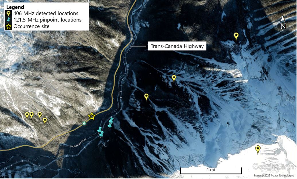
In this occurrence, the ELT activated. It was ejected from the occurrence helicopter and was no longer attached to its external antenna. The JRCC received a 406 MHz signal that provided multiple GPS coordinates within a radius of 2.5 NM of the helicopter (Figure 7). The SAR aircraft were unable to detect a 121.5 MHz signal at higher altitude and, although the ground SAR were able to detect the signal on the ground, they were unable to pinpoint the location until the Cormorant helicopter was able to assist when the weather improved on 07 January.
The TSB Engineering Laboratory in Ottawa, Ontario, examined the ELT and determined that the 406 MHz signal performed within specifications, but the 121.5 MHz signal transmitted for approximately 10 seconds within specification and then stopped. The 121.5 MHz signal did not transmit for the remainder of the test, and investigators could not determine the reason for the malfunction.
Despite the loss of the external antenna, the 406 MHz ELT signal successfully transmitted initial position information to the JRCC likely because of the ELT’s internal antenna design. However, the heavily treed mountainous terrain, the unfavourable weather, the snow-covered wreckage, and the degraded 121.5 MHz ELT signal likely delayed rescue teams in locating the accident site.
Controlled flight into terrain
Controlled flight into terrain (CFIT) “occurs when an airworthy aircraft under the control of the flight crew is flown unintentionally into terrain, obstacles, or water, usually with no prior awareness by the crew.”Flight Safety Foundation, “Controlled Flight Into Terrain”, at https://flightsafety.org/toolkits-resources/past-safety-initiatives/controlled-flight-into-terrain-cfit/ (last accessed on 22 April 2025). This type of accident often occurs in low visibility, at night, or in poor weather. These conditions reduce the pilot’s awareness of the surrounding area and make it difficult to determine visually the aircraft’s proximity to terrain.
In addition, factors such as flight experience, instrument training, and aircraft equipment must be considered during pre-flight planning to mitigate in-flight hazards, such as encountering deteriorating weather conditions. Furthermore, lapses in decision making, maintaining situational awareness, and interpreting changing weather conditions may compromise the safety of a flight in challenging conditions and increase the likelihood of CFIT.
In uncontrolled airspace, the regulations authorize VFR helicopter pilots to operate below 1000 feet AGL with visibilities of 1 SM during the day and 3 SM during the night with or without instrument flight training or basic instruments. In all cases, the helicopter must be operated clear of cloud.Transport Canada, SOR/96-433, Canadian Aviation Regulations, paragraph 602.115(d).
TC’s Helicopter Flight Training Manual provides guidance on instrument flying and identifies that private and commercial pilot training is “designed to assist the pilot who is not IFR [instrument flight rules] qualified […] to transition back to visual meteorological conditions from inadvertent IMC.”Transport Canada, TP 9982, Helicopter Flight Training Manual, Second edition (June 2006), Exercise 30 – Instrument Flying, p. 120. If a pilot encounters IMC such as local fog, the manual suggests that the pilot initially revert to instrument flight to maintain control of the helicopter before performing a 180° turn and continuing with instrument flight in the opposite direction until visual meteorological conditions are regained.
In this occurrence, the pilot performed multiple 360° left-turn orbits before striking terrain. After each orbit, the pilot rejoined the south side of the highway and continued flying toward Revelstoke at approximately 50 to 100 feet above the trees.
TC’s Helicopter Flight Training Manual also states that “[u]nless you are over extremely inhospitable terrain you can normally find a suitable area and land until the weather moderates.”Ibid., Exercise 20 – Weather, p. 87. The Trans-Canada Highway between Golden and Revelstoke has several opportunities for an emergency landing, such as multiple large parking lots at the Rogers Pass visitor centre, and several pullouts for vehicles along the highway.
The Transport Canada Aeronautical Information Manual contains the following warning in bold font regarding low flying:
Warning — Intentional low flying is hazardous. Transport Canada advises all pilots that low flying for weather avoidance or operational requirements is a high-risk activity.Transport Canada, TP 14371E (2023-2), Transport Canada Aeronautical Information Manual, AIR - Airmanship (05 October 2023), section 2.4, p. 401.
The hazards associated with continuing VFR flight into IMC are well documented. Accidents involving flights that depart under visual meteorological conditions and continue to a point where pilots lose visual reference with the horizon have a high incidence of fatality. According to data collected by the TSB, these types of flights have resulted in 123 accidents and 139 fatalities in Canada from 1999 to 2023.
TSB laboratory reports
The TSB completed the following laboratory reports in support of this investigation:
- LP007/2024 – NVM Data Recovery - GPS
- LP015/2024 – Annunciator Panel Analysis
- LP041/2024 – ELT Analysis
Safety messages
When planning any VFR flight, pilots should conduct a thorough review of the expected weather along the route and its effects on their ability to maintain visual reference to the ground, taking into account that the required minimum visual meteorological conditions may not be sufficient for their own experience-based limits.
Continued flight in deteriorating weather conditions can lead to disorientation and CFIT. All pilots—no matter how experienced they are—must take early, decisive action when conditions are not suitable for continued flight.
This report concludes the Transportation Safety Board of Canada’s investigation into this occurrence. The Board authorized the release of this report on 04 June 2025. It was officially released on 24 July 2025.
